Abstract

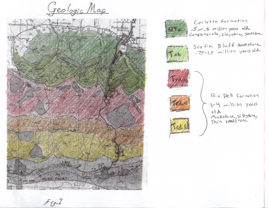
fig. 1
A geologic map of the Wildcat Formation |
In order to describe the geology of the Wildcat Formations, we visited three sites which represent different levels of the strata. These sites are located at 40° 32' 37.9" N, 124° 15' 55.1" W for site #1, 40° 33' 6.1" N, 124° 16' 25.0" W for site #2, and 40° 33' 52.8" N, 124° 16' 16.6" W for site #3. We took samples from each of the sites and calculated the relative depth in the strata represented by each sample. Fig. 1 describes the locations of the three sites, as well as the formations from which each sample was taken. As the site markers indicate, samples were taken from the Carlotta Formation, the Scotia Bluff Sandstone, and the Rio Dell Formation. These formations range in age from 0.5 million years old to 4 million years old and consist, primarily, of sandstone.
Procedures
Field Methods:
Field Equipment
- Brunton Compass
- Ziplock Bags
- Measuring Rod
|
|
Field Procedures
- We used the GPS to find the locations of the three sites
- We measured the thickness of the strata at site #1
- We measured the strike and dip of the strata
- We collected samples from site #2 and site #3
- We collected samples from 5 adjacent layers at site #1
Lab Methods:
Lab Equipment
Lab Procedures
- We built a table containing the grain size and composition of each sample
- We constructed a stratigraphic column of the five samples from site#1 (fig. 3)
- We calculated the relative depths in the strata of the three sites
- We constructed a stratigraphic column showing the relative depths of the three sites (fig. 4)
General Description of Samples
| Sample |
Grain Size |
Color |
Sorting and Rounding |
Composition |
Fossils |
Layer Thickness |
| A |
very fine sand (0.0625mm to 0.125mm) with some silt |
Gray |
Well-rounded
Well-sorted |
Mostly quartz |
Small fragments |
At least 50cm |
| B |
Primarily fine sand (0.25mm to 0.5mm) |
Gray |
Well-rounded
Well-sorted |
Mostly quartz |
None |
35cm |
| C |
Silt (less than 0.0625mm) |
Gray |
Well-Sorted |
Biotite Quartz |
Unknown fossils |
40cm |
| D |
very fine sand (0.0625mm to 0.125mm) |
Gray |
Well-sorted |
Quartz, Biotite, Unknown fragments |
None |
50cm |
| E |
Silt (less than 0.0625mm) |
Brown |
Well-sorted
Well-rounded |
Silt
Small fossils |
Small fossils |
50cm |
| Site #2 |
Silt (less than 0.0625mm) |
Gray |
Well-sorted
Well-rounded |
Sand, Silt, Small fossils |
Fossil fragments |
NA |
| Site #3 |
Poorly-sorted (0.125mm and up) |
Brown |
Poorly-sorted |
Muscovite, Pyrite, Amphibole, Quartz, Clasts (Chert and Graywacke) |
None |
NA |
Table 1
A table of the strata at the three sites, with 5 samples taken from site #1 |
Results
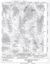
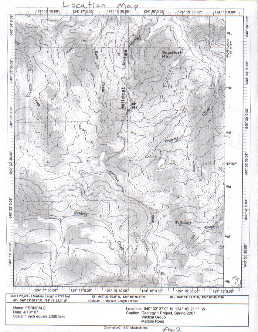
fig. 2
A topographic map of
the Wildcat Formation area |
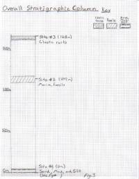
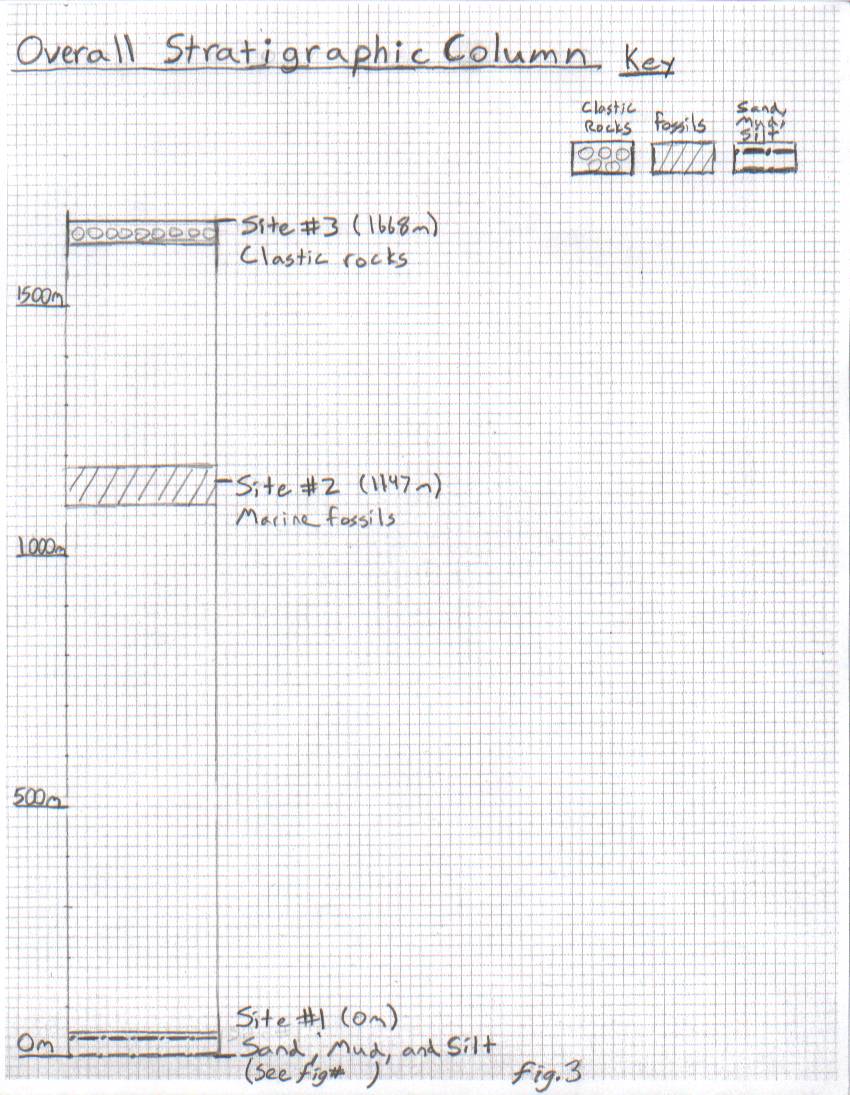
fig. 3
A stratigraphic column showing
the relative depths of each
site within the strata |
Fig. 2 shows a topographic map of the area where the three sites, from which we took samples, are located. We determined the relative positions of the sites by using the dip of 20 degrees and the distance between each site. In fig. 3, the relative depth of each site within the strata is shown.
The three sites represent different periods of geologic time. Site #1 is the oldest of the three. It is made up of alternating layers of coarse and fine sandstone. Site #2 is made up of sandstone containing many fragments of marine fossils. Site #3 contains large rounded clasts of chert and sandstone. It is the youngest of the three sites.
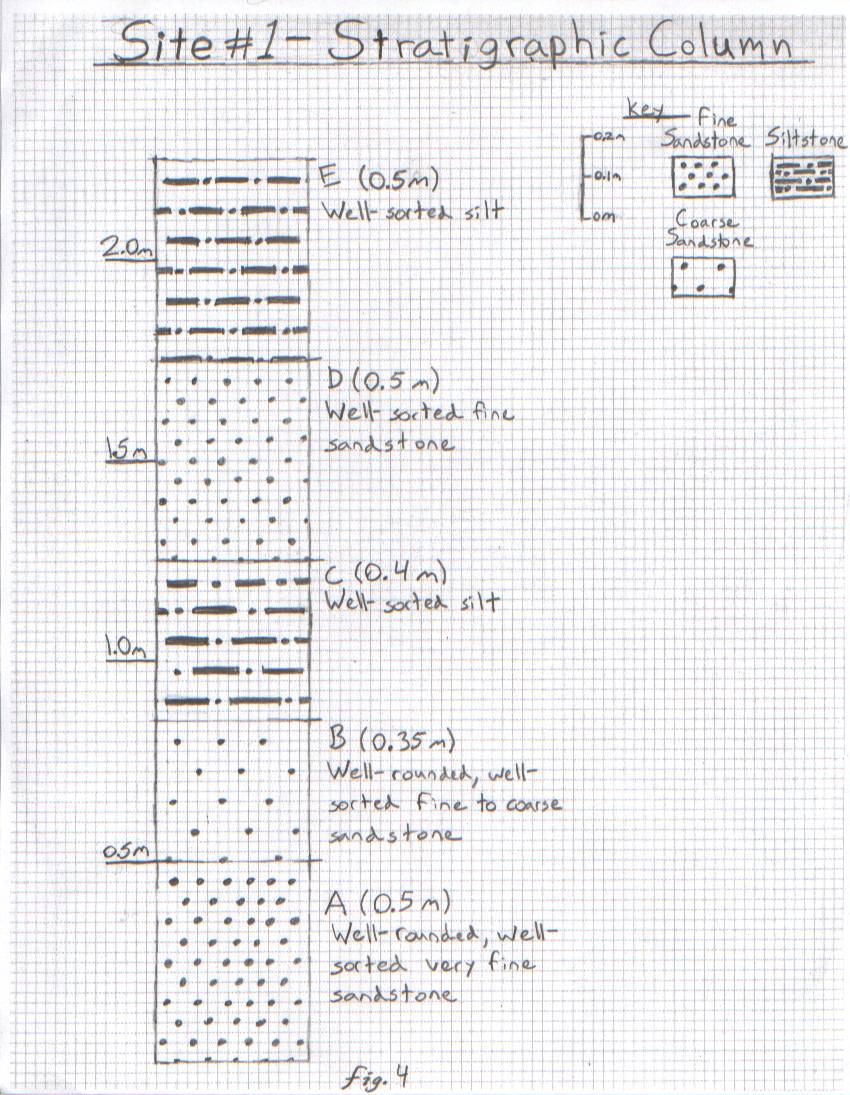
At site #1, we measured the strike to run east to west, and the dip to be 20 degrees. We also measured several layers of sandstone at the site and placed them into the data table. The layers were roughly 0.5m thick and alternated between coarse and finer sandstone. Fig. 4 shows the placement of the 5 layers we measured in more detail. Table 1 gives more information on exactly what those layers contained.
Interpretation
Site #1 is located in the Rio Dell Formation. It is the oldest of the three sites, with an estimated age between 1 and 4 million years old. This formation was about 1000m underneath the ocean when it formed, as indicated by the small grain size of the strata. We decided to take samples from five of the layers at this site and analyze them individually. The results are included in the sample description table, table 1, and are labeled A through E.
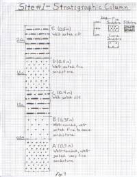
Fig. 4
A stratigraphic column of samples
from site #1
Fig. 4 shows the relative position of each layer, as well as its composition. The data are indicative of turbidite deposits. When ocean water contains a lot of suspended particles, it becomes denser. This dense water moves down slopes in the ocean, continually collecting additional minerals until it reaches a flat area where it can settle. The minerals which settle out of the ocean are called turbidite deposits. The larger particles settle out first, with the smaller particles settling on top. The alternating half-meter layers of larger and smaller sand particles show that this process occurred many times, filling up the bottom of the basin. Eventually, the water was only about 30m deep. At this point, the depositional environment was quite different.
Site #2 is located at the border of the Scotia Bluff Sandstone and the Rio Dell Formation. The strata at this location are 1147m above those at site #1. It is estimated to be roughly 1 million years old. The samples at site #2 consist, mainly, of fine sand and silt. Also present within these samples are large fragments of marine fossils. Such fossils are found all along the Scotia Bluff Sandstone area. The fossils, along with the massive quality of the sandstone, indicate that the area was submerged in shallow ocean water, which probably resulted from the basin being filled up with turbidite deposits.
Site #3 is located in the Carlotta Formation. The strata at this location are 1668m above those at site #1. This area is about 0.5 million years old, which is a lot younger than site #2. It contained clastic rocks with well-rounded pebbles of chert and sandstone. These clasts are indicative of a river. Because this area was being pushed up, it was eventually brought out of the ocean. After this, a river cut through the area, depositing a layer of round pebbles.
The uplift of the beds is the result of compression. Much like a piece of paper being pushed up when both sides are moved toward each other, the strata are lifted up because they are being folded. Water being leeched increases the weight of the strata while also weakening them, causing erosion. Because all of these deposits are so young, they have not had time to cement very well. This makes it easier to collect samples, though.
This project has taught me to check the strike and dip of land before buying it to make sure that the slope and dip are not parallel. I also learned about the history of the Wildcat formation.
References
U.S. Department of Interior, Geological Survey, 1959, Ferndale Quadrangle, California-Humboldt Co., 7.5 Minute Series Topographic Map.
McCory, P.A., 2000, Upper plate contraction north of bigrating Mendocino triple junction, northern California: Implications for partitioning of strain, Tectonics, vol. 19, no. 6, p. 1144-1160
Turbidite - Wikipedia, the free encyclopedia (http://en.wikipedia.org/wiki/Turbidite multiple authors, retrieved 04/28/07)